
Land Registry Lease Plans Gillingham | Land Registry & Lease Plans for Property – Land Registry Plan & Lease Plans by Land Experts
- Monday to Friday: 08:30 till 17:30
- 0800 494 7023
Land Registry Lease Plans in Gillingham — Done Fast and Done Right
Splitting a property, selling a flat, or registering a lease? We create precise, compliant lease plans that meet Land Registry standards and keep your sale or legal process moving — We cover Gillingham and surrounding areas.

Land Registry Lease Plans in Gillingham — Done Fast and Done Right
Splitting a property, selling a flat, or registering a lease? We create precise, compliant lease plans that meet Land Registry standards and keep your sale or legal process moving — We cover Gillingham and surrounding areas.
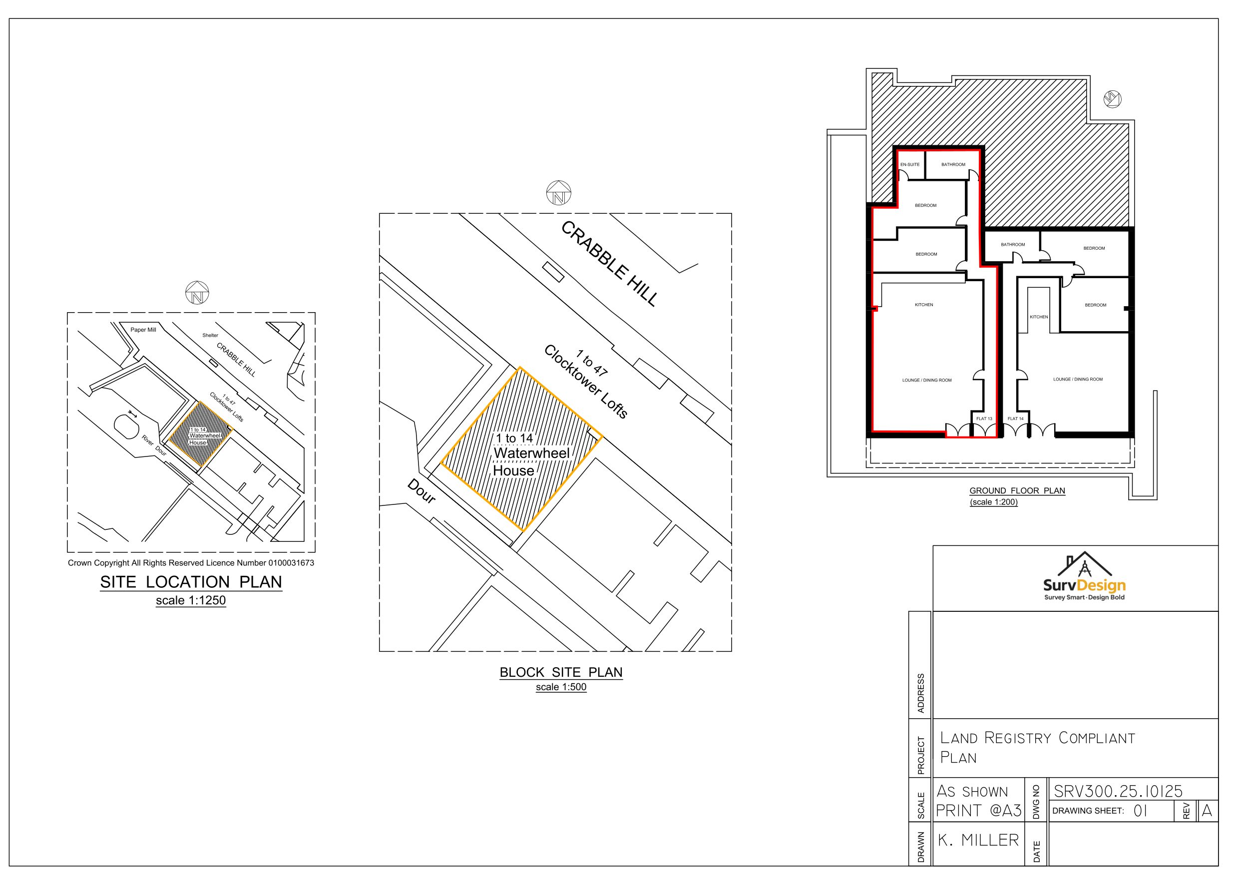
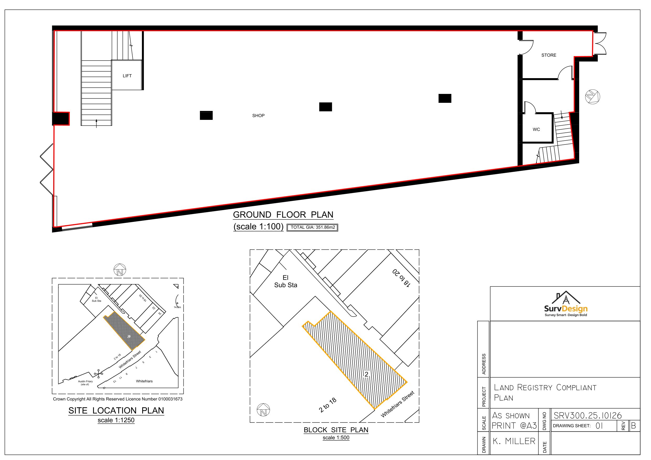
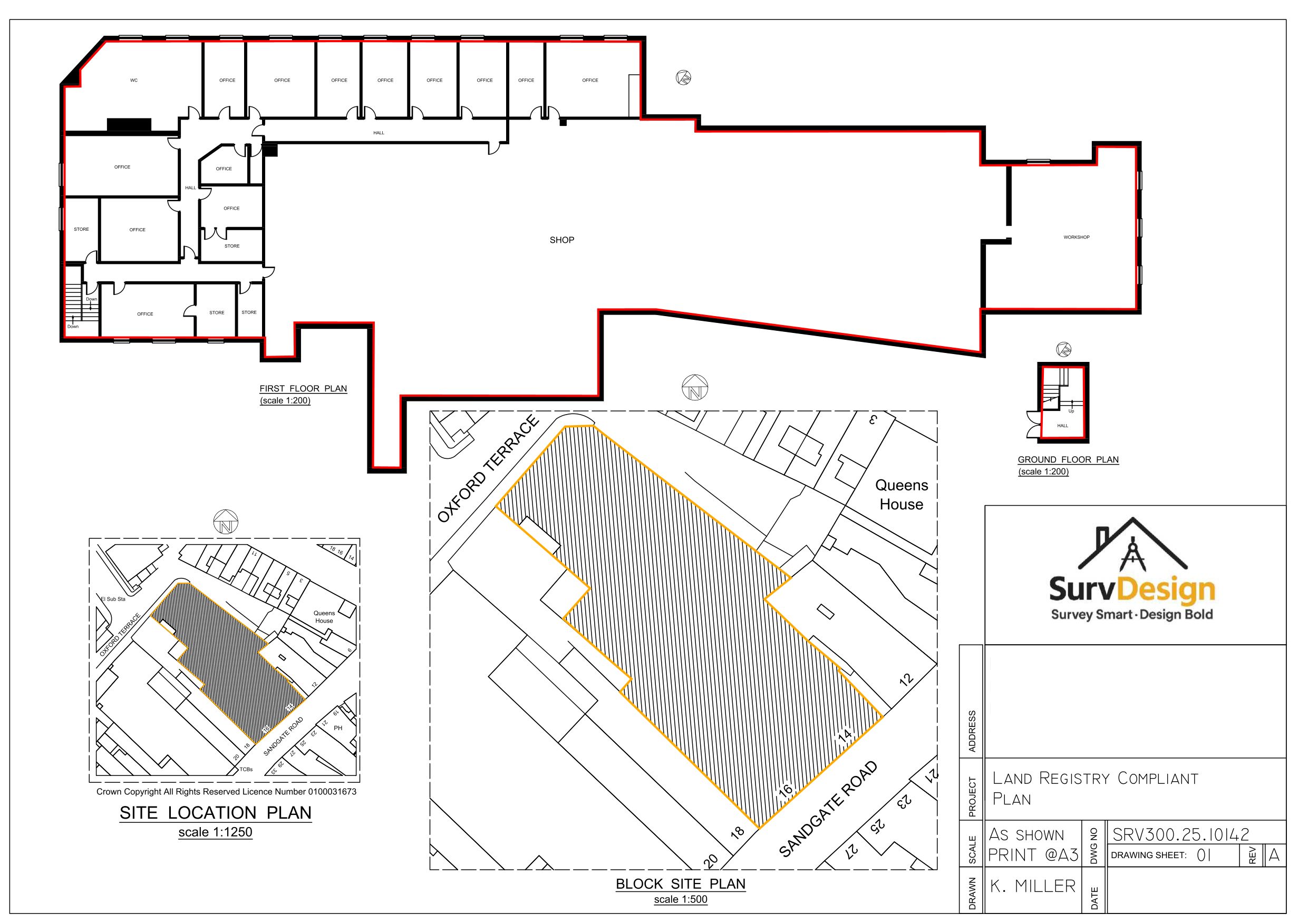
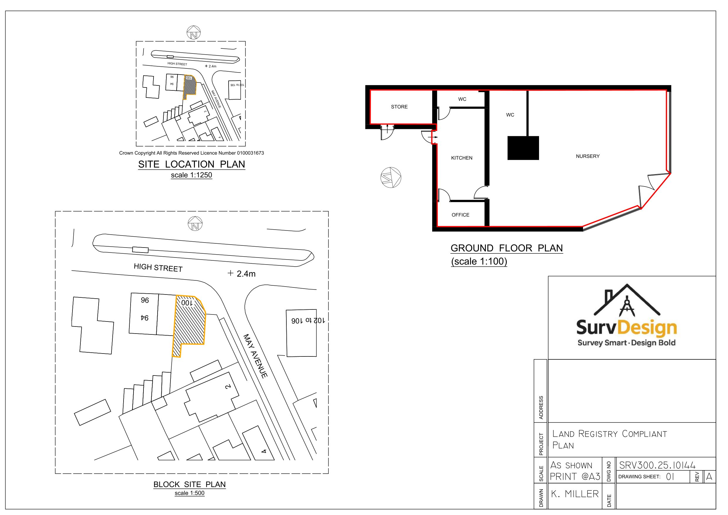
Land Registry Compliant Lease Plans Gillingham - Precision Plans At Unbeatable Value

We Make Measuring Your Property Effortless
No tape measures. No handheld lasers. We use LiDAR scanning technology — the same used in self-driving cars — to capture your home with millimetre precision. That means zero guesswork, zero stress, and a perfect foundation for your plans.
We Create Your Land Registry Plans
We turn your scan into ultra-precise, land registry compliant drawings — typically within 2 working days. The level of accuracy our surveys provide is unrivalled by traditional methods.
100% Guaranteed Land Registry Compliance
Our Land Registry compliant plans include every thing you need to guarantee Land Registry Compliance for all of your property needs.

We Are Proudly Rated 5 Stars on Google
🧠 “The Solicitor’s Asking for a Lease Plan — And I’ve Got No Idea Where to Start.”
We get this a lot. Maybe the old plan’s out of date. Maybe there’s never been one. Or maybe you’re renewing a lease and suddenly need to provide one yesterday. Either way, we’ll handle it.
Is my current plan compliant?
What does the Land Registry actually require?
Will this delay the sale or lease renewal?
🛠️ What We Do
We create accurate, professional lease plans that meet Land Registry standards, solicitor requirements, and legal deadlines. Whether it’s a one-bedroom flat or a multi-unit commercial site, we’ll get it measured, drawn, and delivered — fast.
We use LiDAR scanning and CAD software to capture every detail precisely and present it exactly as required.
📄 Our Lease Plan Service Covers:
🏠 Residential Lease Plans
Perfect for leasehold sales, shared ownership, first registrations and subletting.
Flats & maisonettes
Converted houses
New builds
Shared access & common parts clearly marked
Scaled, coloured, and formatted for Land Registry
🏢 Commercial Lease Plans
Ideal for renewals, changes in tenancy, new occupiers, or expanding premises.
Offices, shops, restaurants, warehouses
Clearly marked demise & access
Multiple tenancies in one building
Delivered in digital format for legal teams
📦 What’s Included:
✅ Scaled at 1:100 or 1:200
✅ North point & orientation
✅ Red line demised boundary
✅ Blue line for shared or retained areas
✅ Annotated with room usage, access points & entrances
✅ Fully compliant with Land Registry requirements
✅ Supplied digitally as PDF (print-ready if needed)
✨ Peace of Mind, Delivered
No back-and-forth with solicitors. No last-minute headaches. Just a clean, clear lease plan that’s fully compliant and ready to go.
We’ve helped hundreds of residential and commercial clients get over the finish line — and we’ll do the same for you.
🙌 Let’s Get Started
Need a lease plan fast? We’ll give you a fixed quote and get things moving.
📞 Call Kev and his team on 0800 494 7023
♻️ Our Eco-Friendly Approach
At SurvDesign, sustainability isn’t a box-ticking exercise — it’s embedded in how we operate. We work with residential and commercial clients who value precision, efficiency, and a forward-thinking approach to design and documentation.
By using LiDAR scanning, we reduce the need for multiple site visits and eliminate outdated, waste-heavy survey methods. Our entire workflow is digital-first — from CAD production to plan delivery — meaning fewer resources, less waste, and zero unnecessary printouts.
We collaborate with professionals who value smart, low-impact working. That means remote coordination, clean digital outputs, and a supply chain that reflects modern expectations for carbon-conscious delivery.
It’s not just about getting the drawings right. It’s about getting them done smarter — for you, your clients, and the environment.
Let’s be honest — dealing with planning drawings and council forms probably isn’t what you dreamed of when you imagined improving your home.
That’s where I come in.
I’m Kev Miller, Ive spent the last 28 years helping property owners, builders, and professionals navigate the technical side of construction.
I’ve provided architectural services, structural calculations, and land registry compliant drawings to clients across London and the Home Counties in the South East of the UK.
When you work with us, you’re not just hiring a architectural design team — you’re working with local experts who know the system, speaks the council’s language, and genuinely cares about getting your project moving forward.
This is your home. We’re just here to help you build it right.
Meet Kev Miller, Founder. Problem Solver
Why Gillingham Property Owners Need a Land Registry-Compliant Plan
If you’re buying, selling, leasing, or splitting property in Gillingham, Kent, you’ll need a Land Registry lease plan that meets strict requirements. This isn’t just paperwork — it’s the official map that defines your property’s exact boundaries, any shared spaces, and the relationship to surrounding land. Without it, your transaction can stall.
Whether it’s a town centre flat near the International Station, a commercial unit on Orbital Park, or a family home in Kent, SurvDesign creates lease plans that are solicitor-ready, 100% compliant, and accepted by the Land Registry first time.
Local Knowledge That Speeds Up the Process
We’ve delivered lease plans for properties all over Gillingham — from retail spaces to new-build apartments in Kent. We know what works for both the Land Registry and local solicitors, meaning your plans get approved quickly and without hassle.
Common Lease Plan Mistakes — And How We Avoid Them
No clear boundary lines – every inch of demised property must be marked in red
Shared spaces not shown – bin stores, parking, or hallways must be edged in blue
No scale or wrong scale – we follow Land Registry’s 1:100 or 1:200 rules exactly
Missing north point – every compliant plan must show orientation
Outdated layouts – changes to a property must be reflected accurately in the plan
At SurvDesign, we avoid these pitfalls by combining LiDAR-accurate measured surveys with years of Land Registry expertise. That means your Southend-on-Sea lease plan isn’t just acceptable — it’s bulletproof.
What We Deliver for Gillingham Lease Plans
Fully compliant Land Registry lease plans
Measured surveys for pinpoint accuracy
OS-compliant location and block plans
Correct colour coding for demised and retained land
Fast turnaround with direct delivery to your solicitor
How Accurate Plans Benefit Your Property: Precision with LiDAR Technology
Getting your land registry lease plans right from the start is a game changer when it comes to property deals in Kent. Traditional surveys land you plenty of headaches — missed boundaries, dodgy measurements, and delays from back-and-forth with the registry.
That’s why I insist on using cutting-edge LiDAR scanning for every property and lease plan job. It’s not just about showing where the walls are — it’s about precise, land registry compliant drawings that remove all the guesswork from registry lease plans, keep your property records spot-on, and make life much smoother when you sell, split, or renew that lease.
With the right tech, you get every detail right for both plans and boundaries, ensuring registry compliance and fast approval.
From Survey to Land Registry-Compliant Drawings — The Tech That Makes It Stress-Free
After decades pouring over property, plans, and lease paperwork, I can say nothing’s more frustrating than waiting on plans that get knocked back by the land registry for being out-of-date or unclear. That’s why my team at SurvDesign uses LiDAR scanning for every job — not a tape measure or guess in sight. LiDAR lets us capture your property and boundaries in pinpoint detail, creating land registry lease plans and compliant lease drawings that show the lease area, demised land, and any shared or external spaces. This means when your solicitor, agent, or the registry asks for plans, you’re not left scrambling.
Our surveys land all the critical measurements the first time — every wall, window, entrance, and boundary, mapped down to the millimetre. Then, the data’s turned into registry compliant plans fast, avoiding the sort of red tape that holds up Kent property transactions again and again. From the initial visit to finished lease plans, the LiDAR process means those registry requirements (scaled plans, north points, coloured boundaries, clear lease and retained land markings) are all dialled in — which the registry just loves because it means they don’t have to chase.
There are no missing corners, no fuzzy boundaries, and no “nearly right” plans that cause a registry rejection. It’s fast, stress-free, and above all, it gives you the confidence that your property, plans, and land records aren’t just “fine” but fully registry compliant. For Kent owners, landlords, or anyone needing plans land registry accepts straight away, this tech is what keeps your move, lease renewal, or property split on track from start to finish — no more squabbles over boundaries or registry delays, just a solid result every time.
Title Plan vs Lease Plan: Know Your Documents for Registry Success
If you’re sorting out a property or lease in Kent, it’s vital to understand the difference between a title plan and a lease plan — two documents that get chucked about all the time in land registry paperwork, but mean very different things when it comes to keeping your registry journey headache-free. A title plan is the official drawing the Land Registry attaches to the freehold title of your property — it shows broadly where your land and property sit on the Ordnance Survey map, with a red line around your ownership.
The lease plan, on the other hand, is far more detailed and laser-focused: it’s the plan you need if you’re selling, splitting, or leasing a flat, commercial unit or that quirky mix-used Kent property. This plan dives deep into the nitty-gritty, clearly marking out every inch covered by your lease, alongside shared or communal spaces, with boundaries drawn and coloured to strict land registry standards.
Why does this matter for Kent property and registry lease plans? Well, mixing up plans, or submitting just a title plan when the registry needs a compliant lease plan, is a recipe for delays — I’ve seen deals collapse or grind on for weeks just because the wrong plan got sent. The title plan shows the whole property’s land, but your lease plan zooms into the parts actually let, detailing entrances, access points, and shared bits.
Every registry submission — from an initial land registration to a brand-new lease — hinges on sending in the right plans. At SurvDesign, we make sure your property’s title plan and lease plan each play their part, so you’re not left explaining to your solicitor (or the registry) why the plan submitted doesn’t measure up.
With the right plans, Kent owners can breeze through land registry requirements, confident their lease, property, and every registry plan is bang on spec — and done right, first time.
Guaranteeing a Compliant Lease: Land Registry Checklist from the Experts
Making sure your Kent property’s lease plan ticks every land registry box isn’t just about avoiding stress — it’s about securing a smooth property transaction and ironclad compliance. Over nearly three decades in property, I’ve cracked the code for what the registry expects with each lease: it’s not just having any old plans or a rough sketch, but producing a land registry lease plan that stands up to all registry guidelines, every single time. Let’s break down the checklist that keeps your lease, property, and land in line with the registry’s rules.
First, your plans must show the exact boundaries covered by the lease — that means clear, coloured demised areas in red, shared or retained land in blue, and proper scaling (usually 1:100 or 1:200) so the registry can check dimensions with confidence. Every lease plan needs a north point, access routes, and a legend clarifying all markings — miss one step and the registry might bounce your plans for being non-compliant. Whether it’s a residential flat or a warehouse, plans must show entrances, room uses, and anything included in the lease, like parking or gardens. The checklist is as much about accuracy as it is about format: if your plans lack clarity, the registry or your solicitor will spot the problem and raise queries or delays. That’s why SurvDesign deploys precise LiDAR surveys — every property and land detail is captured in a way that meets or exceeds registry requirements, every time.
So, if you want your Kent lease to pass first time, make sure your registry lease plan is detailed, scaled, and follows every registry rule. Rushing leads to rejected plans and stalled property deals. With our team, you’re working with people who live and breathe compliant lease documentation — and we wouldn’t let anything less than registry-perfect plans leave our hands. This attention to detail on every checklist point protects your lease, your property value, and the land you own or let — and, crucially, gets your plans through the Kent registry fast, so your transaction keeps moving.
Frequently Asked Questions About Land, Lease, and Registry Plans in Kent
Over the years, sorting property, land, and lease paperwork in Kent has raised plenty of questions — so you’re not alone if the world of land registry lease plans sounds a bit baffling. Let’s tackle a few of the most common queries I get from Kent owners, landlords, and property professionals struggling to make sense of these plans, and make the registry process a breeze.
What exactly is a land registry lease plan, and do I really need one for every property transaction? In short: yes, you do. Any time you’re buying, selling, splitting, or renewing the lease on a property in Kent, the land registry requires precise lease plans showing exactly what land and property boundaries are involved. This keeps your lease and registry paperwork compliant, ensuring the entire process moves smoothly.
What needs to be included for a plan to meet Kent land registry standards? The plans must accurately mark all property boundaries, the lease area, and any land that’s shared or retained. Registry-compliant plans are scaled, contain a north point, colour coding, and clear demarcation of each lease’s demised land. If the registry spots anything missing, your plans will be rejected and your property transaction delayed. That’s why, here at SurvDesign, we use advanced tech and local know-how to guarantee compliance for every Kent lease and property, every time.
How do you make sure your lease plans get accepted by the land registry? Simple: we never cut corners. Our LiDAR surveys capture your land and property with unbeatable accuracy, and our experienced team produces plans that nail every registry requirement. Whether it’s a new lease, property split, or first-time registry, you can trust our plans to deliver fast results across Kent.
Ready for Your Land Registry Plan? Let’s Get Your Lease Plans Done Right
If you’re ready to take the plunge with your land registry lease plans in Kent, let’s make sure your plans aren’t just done quickly, but done properly — the first time. After nearly three decades spent guiding Kent owners, solicitors, and property pros through the technical maze, I’ve learned exactly what makes a compliant lease plan: accuracy, clarity, and no shortcuts. Every property, lease, and bit of land in Kent deserves plans that tick all the registry boxes, so your transaction isn’t stalling at the solicitor’s desk waiting for updates or corrections. SurvDesign’s approach is simple: from our first LiDAR scan right through to your completed plans, you get professional, registry-compliant lease plans that lawyers and the Land Registry recognise as gold standard. That’s peace of mind during high-pressure transactions, knowing your lease and land documentation will get you past legal checks without the dreaded “plan not accepted” email.
We understand that every Kent property, lease, and registry submission comes with its own quirks. Whether you’re registering a flat in a busy part of town, splitting a converted house into new leases, or sorting commercial premises plans for changing tenants, you need plans and registry documents built for the real world. Our lease plans are specifically crafted for Kent land, meeting every detail demanded by registry guidelines so you can move quickly — and without worry — through sales, purchases, or renewals. With SurvDesign, you avoid the common stumbling blocks: our plans show every boundary, shared access, demised land, and all those coloured lines and north points the registry loves. We’ve made it our mission to ensure your lease, registry submission, and every transaction is sorted with just one visit and one set of plans — all fully compliant and trusted by Kent solicitors from day one. So when your next registry challenge lands, you know our plans will get your Kent property precisely where you need it: safely across the line, with no extra hassle.